


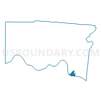
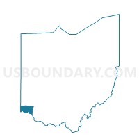
Voting District ANDERSON UU, Hamilton County, Ohio
About
Outline

Summary
| Unique Area Identifier | 647031 |
| Name | Voting District ANDERSON UU |
| County | Hamilton County |
| State | Ohio |
| Area (square miles) | 1.80 |
| Land Area (square miles) | 1.64 |
| Water Area (square miles) | 0.16 |
| % of Land Area | 91.06 |
| % of Water Area | 8.94 |
| Latitude of the Internal Point | 39.06140280 |
| Longtitude of the Internal Point | -84.40260620 |
Maps

Graphs
Select a template below for downloading or customizing gragh for Voting District ANDERSON UU, Hamilton County, Ohio


Neighbors
Neighoring Voting District (by Name) Neighboring Voting District on the Map
- Voting District ANDERSON D, Hamilton County, OH
- Voting District ANDERSON E, Hamilton County, OH
- Voting District ANDERSON F, Hamilton County, OH
- Voting District ANDERSON H, Hamilton County, OH
- Voting District ANDERSON J, Hamilton County, OH
- Voting District ANDERSON X, Hamilton County, OH
- Voting District CINCINNATI 1-A, Hamilton County, OH
Top 10 Neighboring County Subdivision (by Population) Neighboring County Subdivision on the Map
- Cincinnati city, Hamilton County, OH (296,943)
- Newport-Fort Thomas CCD, Campbell County, KY (68,138)
- Anderson township, Hamilton County, OH (43,446)
Top 10 Neighboring Place (by Population) Neighboring Place on the Map
Top 10 Neighboring Unified School District (by Population) Neighboring Unified School District on the Map
- Cincinnati City School District, OH (330,202)
- Forest Hills Local School District, OH (46,156)
- Silver Grove Independent School District, KY (1,508)
Top 10 Neighboring State Legislative District Lower Chamber (by Population) Neighboring State Legislative District Lower Chamber on the Map
Top 10 Neighboring State Legislative District Upper Chamber (by Population) Neighboring State Legislative District Upper Chamber on the Map
Top 10 Neighboring 111th Congressional District (by Population) Neighboring 111th Congressional District on the Map
Top 10 Neighboring Census Tract (by Population) Neighboring Census Tract on the Map
- Census Tract 250.02, Hamilton County, OH (7,333)
- Census Tract 531, Campbell County, KY (5,810)
- Census Tract 529, Campbell County, KY (5,362)
- Census Tract 251.04, Hamilton County, OH (1,843)
- Census Tract 45, Hamilton County, OH (1,064)